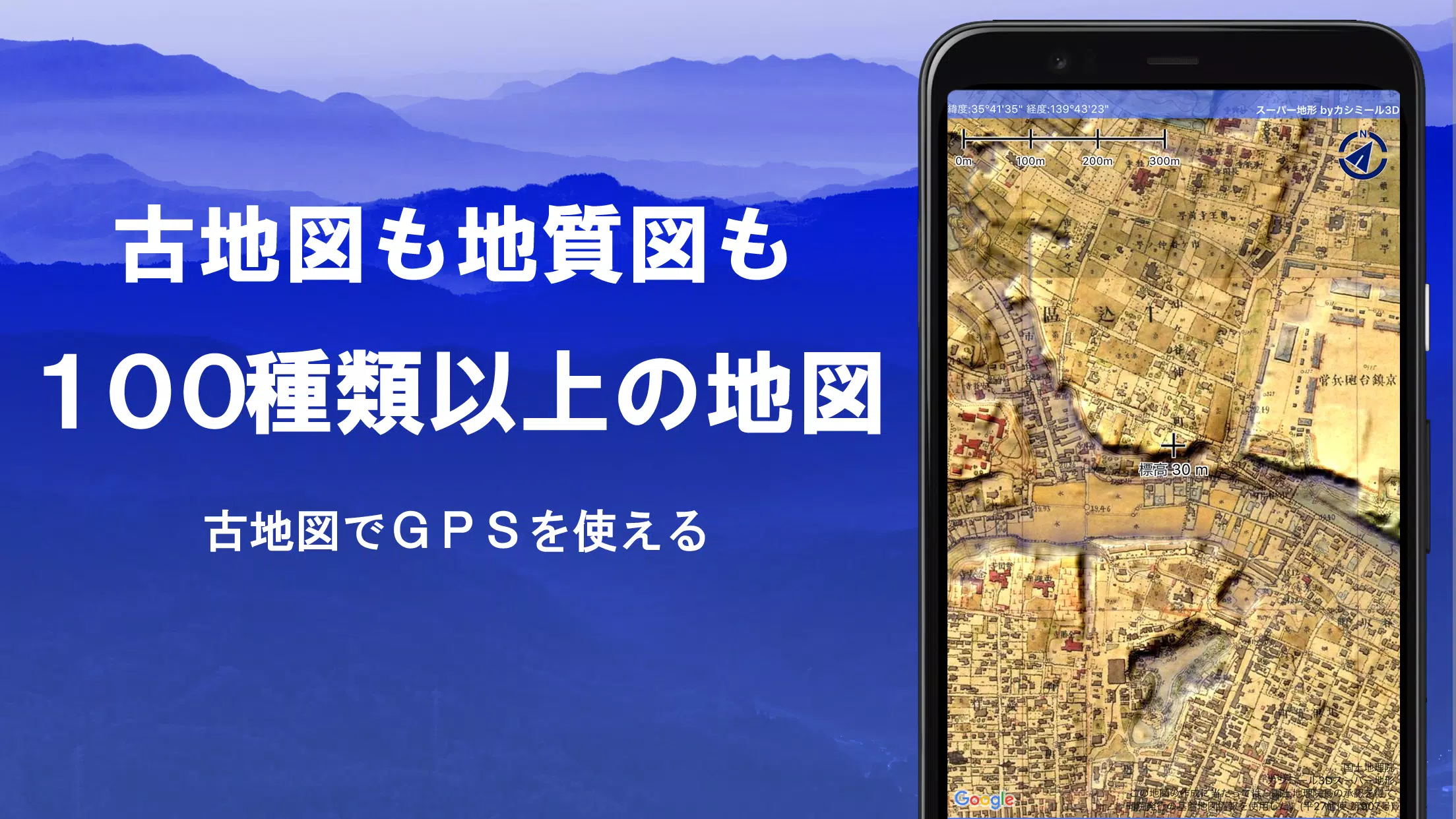
Discover a world of exploration with over 100 types of maps at your fingertips, including those from the esteemed Geographical Survey Institute. Whether you're scaling mountains or strolling through urban areas, these maps leverage height differences to enhance your journey. Our application was honored with the 2018 Japan Cartographic Society Award for Best Work, a testament to its quality and utility.
Dive into our unique "super terrain data" feature, which accentuates the terrain through cutting-edge technology. Utilize a wide array of maps from the Geospatial Information Authority of Japan, encompassing topographic, geological, historical, and even prewar Ordnance Survey Department maps. Record your adventures with precision using the GPS function, which supports GPX log input, output, and editing.
Enhance your outdoor experience with dedicated functions for urban walking, mountain climbing, and other activities. These include GPS navigation with audio cues, data recording, and editing capabilities. Benefit from the visibility determination feature for cross-sectional diagrams, observation, and radio use, with the added option to display buildings.
Experience a 360° panoramic view that identifies mountains and shows the positions of the sun, moon, and GPS points. Enjoy seamless offline use with bulk map downloads and map caching, perfect for areas without radio signals. Additionally, you can associate photos with specific locations, view contour lines generated from elevation data, and display MGRS grids (UTM grids).
Our app supports reading, displaying, and editing GIS data from GeoJSON files, drawing shapes, and can be used internationally. Features like map printing and PDF output, along with a dark theme, add to the versatility of your experience.
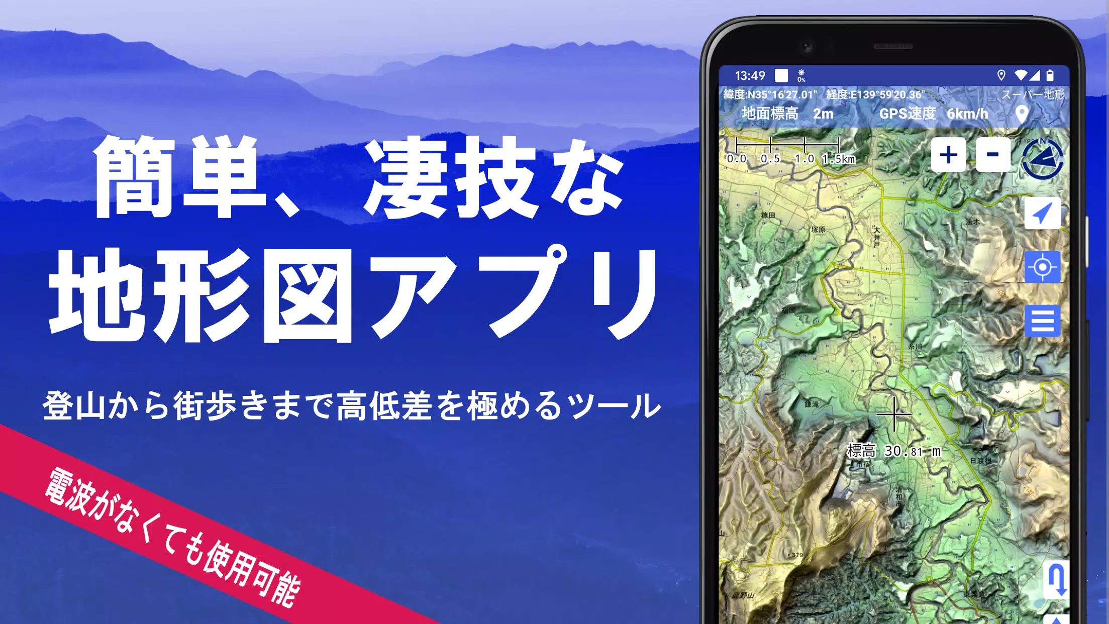
A Wealth of Maps at Your Disposal
Explore over 100 map types, including our exclusive super topographic data and maps from the Geospatial Information Authority of Japan. Note that aerial photographs may have varying coverage by age group, with "Latest" and "around 1974" offering broader areas. Enjoy free access to maps using super terrain data for 5 days after installing the app.
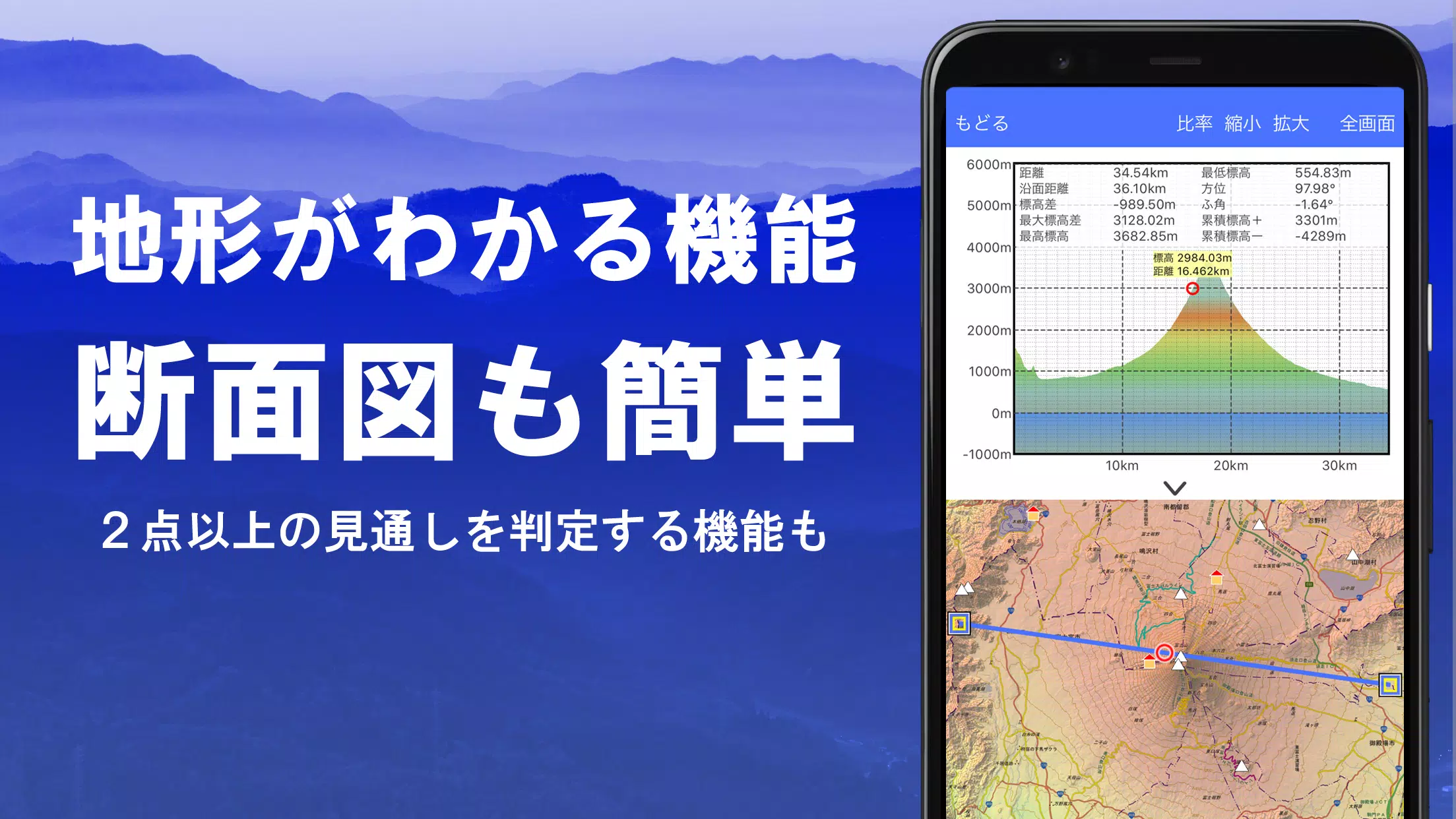
Creating Cross Sections and Outlooks
Effortlessly draw cross sections through any point on the map and utilize the advanced visibility judgment function to account for Earth's curvature and atmospheric differences. This feature is invaluable for route planning during climbs, assessing radio visibility, and understanding terrain. Where PLATEAU building data is available, incorporate buildings into your cross-sectional views.
Elevation Palette Function
Customize your map's background color with the elevation palette function, allowing you to set your preferred color gradation in 1cm increments.
Panoramic View
Identify mountains with ease using our panoramic observation map, which integrates with your smartphone's compass for a full 360-degree view. Explore celestial phenomena like Diamond and Pearl Fuji, and view GPS point locations. Extend your reach by drawing panoramic views of mountains abroad.
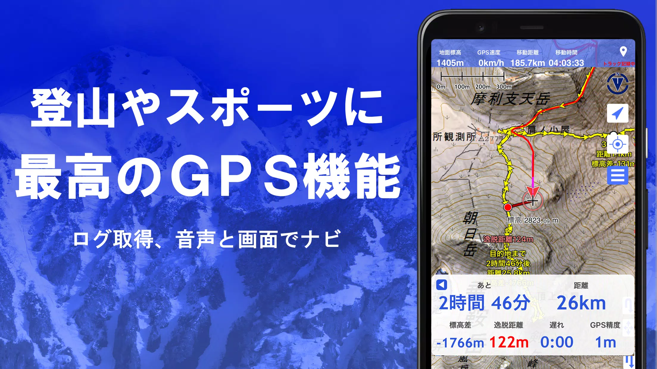
GPS Function
Harness the power of your smartphone's GPS to track your location and record your journeys with high precision, suitable for serious outdoor and mountain activities. Visualize your tracks with detailed parameters such as elevation change, speed, time, and elapsed time. Receive voice and alarm notifications when nearing designated points, and view photos linked to specific locations. Share your map center position with NaviCon.
GPS Track Summary Playback
Replay your tracks seamlessly, with automatic photo display based on their capture times. Icons mark photo locations for easy access.
GPS Navigation Function
Navigate along pre-set tracks with the Track Navi function, receiving alerts if you stray from your path. This ensures you stay on course during climbs. Additionally, utilize route navigation for urban exploration and point navigation to reach specific destinations.
GPS Data Editing Function
Manage GPS-related data for points, routes, and tracks, organized in an easy-to-read tree format. Create tracks directly on the map and import/export data in GPX format from various climbing sites.
Map Usage Outside the Service Area (Offline)
Continue your adventures even in areas without a signal, thanks to our bulk download feature that ensures all necessary scale maps are available. A clear overview of downloaded maps prevents surprises in the field, and a cache function adds to your offline capabilities.
Map History Function
Quickly revisit previously viewed locations with our map history feature, which remembers your past explorations.
Custom Map Compatibility
Import and utilize custom maps created with Kashmir 3D's map cutter. Display and use personal or scanned maps by dividing images into approximately 256 x 256 segments, then sending the resulting kmz file to Super Terrain via email or Cloud Drive.
GeoJSON Compatibility
Work with points, linestrings, and polygons from GeoJSON files, including the ability to draw new shapes.
Print/PDF Output
Print any map area at your desired scale or save it as a PDF for future reference.
Integration with Other Apps
Seamlessly exchange GPS data in GPX, KML, and GDB formats with other apps, including Kashmir 3D on your PC, and utilize track data from climbing websites.
Backup Function
Safeguard your data with our comprehensive backup feature, which excludes cached maps. Restore your data even if you delete the app or encounter device issues. Automatic backups via Google Drive ensure your data remains current.
Billing Function Details
Certain features like super terrain data maps, GPS track functions, and cross-sectional views are available via in-app purchases. Post-purchase, you'll enjoy an increased number of search results for place name searches.
●Fees: Annual payment of 780 yen/year.
●Free Trial: Experience the app for free for 5 days after installation. After this period, some features and maps will require payment, and you will only be charged if you opt for a purchase within the app.
●Confirmation and Cancellation: Check or cancel automatic updates through Google Play under "Regular Purchase" and select "Super Terrain."
●Price Revision: Future enhancements may lead to price changes, making early purchase advantageous.
Terms of Use
The copyright holder and developer are not liable for outcomes related to the use of this application. Upon first use of GPS, allow location services. Continuous GPS usage may deplete your battery, so consider carrying a spare for emergency communication. For an in-depth guide on the navigation function, refer to this PDF: Super Terrain Navigation Guide. Note that some smartphones may interrupt or fail to record tracks due to power-saving features, a common issue across various apps.